Category Archives: Tools & Methodologies

Narrated Visualisation – Russian Modernists


While considering a subject for a project on data visualisation, in order to make the research as relevant as possible to my overall course objectives, I decided to focus on three prominent Russian artists of the early 20th century. Kazimir Malevich, Vladimir Tatlin and Alexander Rodchenko were all important figures in the Russian avant-garde movement of the 1920s. Each working in a variety of art disciplines, generally in the style of geometric abstraction, their work has been highly influential on many artists in the west throughout the 20th century, and they have been the subject of a considerable amount of critical writing outside of Russia. In order to trace the trends of the writing that exists about these artists, I used Google Books Ngram viewer, Google’s online search engine that allows users to search for the frequency of occurrences of particular words in a given language.

The diagram above shows the results of a search for the three names, in the English language corpus, from 1920 (roughly when they first became prominent) to 2008. The graph shows a pretty steady increase of references to all three and then a tailing off, with Tatlin and Rodchenko being particularly equivalent in pattern. There is a marked peak for both around 1990 – 1991, probably related to the collapse of the Soviet Union at that time, which would have afforded Western academics increased access to their works. Also after this point many works from all three artists would have been allowed to travel abroad for the first time in decades to galleries in Europe and elsewhere, generating considerable interest. Another reason for the similarities in Rodchenko and Tatlin’s graphs may be that they were both associated with the same movement, Constructivism. Many books have been written about this specific movement and both would very likely be referenced in such works.

Kazimir Malevich has followed a somewhat different trajectory, remaining a prominent subject for discussion well into the 21st century. He is associated with a separate movement, Suprematism, in which he is by far the most notable figure. He was himself a prolific writer, and among the reasons for his increased popularity may have been the publication in the late 1990s of several volumes of his writings with English translations. There was a major exhibition of his work in Paris in 2002, followed by major retrospectives in Berlin and New York in 2003 and 2004. Such exhibitions generate a good deal of attention and renewed critical writing. In 2014 the Tate Modern gallery in London held a very sucessful exhibition of his work, so his prominence is likely to continue for some time.

I wanted to experiment more with the data from the Google Ngram Viewer. While it’s a great source of information and a very useful tool, I wanted to be able to play around with how the information looks visually, especially given my interest in fine art and aesthetics. There are many good tools available for data manipulation, but I was keen to try a more hands-on approach, so I decided to use the open-source programming language Processing, specifically developed for coding within the context of visual arts. Since my dissertation is likely to heavily feature its use, I also needed to gather more experience with it.

Malevich & pals 1

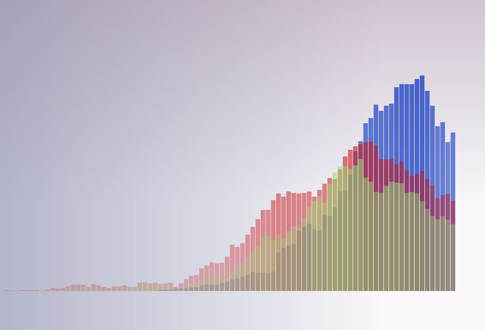
The above diagram was generated with Processing, and contains the same data from the ngram viewer with a different visual approach. The first task was to get hold of the raw data from the graph. Google Ngram Viewer doesn’t appear to have any means to be able to download the data from an individual graph, but I discovered that by viewing the source code of the webpage, the data existed as a distinct array for each search term on the graph. I was then able to insert the information into three separate arrays in my own code. This was a useful exercise as I hadn’t used or written an array before, and I understand the use of arrays will be important to produce sketches with good quality interactivity as I intend to do.

I used the data from the arrays with a for loop to draw the bars with varying length. For clarity, I retained the same colour scheme for each artist used on the Google graph, though I adjusted and desaturated them for aesthetic reasons. I also tied the opacity of each bar to its length, so the colour fades out with lower values, allowing the ones behind to be seen. This also produced a subtle modulation of colour across the graph. Finally I added a couple of for loops to produce gradients in the background for a little more atmosphere, and to contrast with the rigid geometry of the bars.

Malevich & pals 2

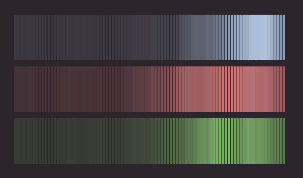
I was particularly interested in the variation in opacity I was able to get from the data, so decided to write another sketch to exploit this further, seen in the diagram above. Here, there is no variation in the length of the bars, but the difference in tone against the dark background has been exaggerated to produce a sort of contour effect.

My visualisations currently have no textual information of course, so arguably have less functional use than the original Google graph. However, in visual form all the raw information is still present, and my goal was to focus on the aesthetics to produce something which could on some level be thought of as an art piece. This was a good learning exercise. It was fascinating to see that when you have the ability to acquire and properly store and retrieve information, it gives you a lot of control over how you present it.

OpenStreetMap

OpenStreetMap is a free to use, collaborative mapping project continually updated by a large community of contributors worldwide.  As it is open data, it is allowed to be used for any purpose, but has come to play an increasingly important role in the area of humanitarian aid. In the aftermath of the 2010 Haiti earthquake, it was quickly used to build a very complete digital picture of the terrain, buildings and roads in the worst affected areas, proving an invaluable resource to aid workers in the region. Since then, primarily through its tasking manager site, humanitarian crises are tracked and prioritised so the large number of subscribed mappers can use satellite imagery and other resources to get important geographical information to aid workers on the ground.

OSM1

I recently set up an account with OpenStreetMap in order to begin contributing to the project. The prospect of getting to grips with the tools was a little daunting at first, but there are some excellent tutorials and introductory videos available on openstreetmap.org which I found to be a great help. Despite the gravity of the work being done the tutorials successfully get across how much the organisers want people to become involved, stressing the value of even a minimal level of involvement, which I found very reassuring.

The process of becoming a contributing mapper is essentially quite simple. After having signed up to the project, you are free to begin contributing to the map of any part of the world you like, by simply searching for the desired location, and choosing to edit it, which can be done with a set of intuitive mapping tools accessible from within your browser. The user interface provides several tools which you can use to add information of different types to a map. With a little practice these provide the means to intuitively trace out and identify a full range of geographical features including houses, roads, residential areas, coastlines and so on. Additional information on the mapped features (if known to the user) can be added using a panel on the left of the screen. I found the interface responsive, uncluttered and user-friendly, with handy keyboard shortcuts mapped to many of the more commonly used functions.

OSM2

Having practiced a little with the tools I visited the OSM Tasking Manager at http://tasks.hotosm.org/ in order to contribute to the ongoing humanitarian work. I decided to work on some regions of the map of Botswana, particularly in Mochudi and Sephare. For each region, there is a detailed description of the type of relief work being carried out in the area and instructions on the particular geographical features to be prioritised. In Botswana, there are many parts of the map where buildings and roads have not yet been marked out. This information is vital to facilitate the ongoing treatment programs which are tackling the high incidence of HIV/AIDS and TB in the country. I’ll admit to a strong initial sense of apprehension before beginning the mapping process,  after all, this work may well have consequences in the real world. However, the process is truly collaborative, and there’s a strong sense of support there. Firstly, the regions are divided into tiles of a manageable size, which can be further subdivided into smaller zones if needed. Secondly, you can save your work at any time and come back later. The tiles are also validated and modified if necessary by more experienced mappers when they are declared finished, (who may well possess more detailed local knowledge), so you never feel that you are working alone.

As part of my current MA in Digital Arts & Humanities, it is my intention to develop a series of interactive, web-based activities in order to teach people about the principles of design in fine art paintings, with particular reference to the geometric abstraction genre. Although OpenStreetMap is an entirely different proposition, I think aspects of the experience of working with it will inform my research. In particular, for any project requiring user interaction, a well designed, easy to grasp user interface would seem to be vital. Enabling the user to render virtually any type of geographical feature they may encounter would seem to be a very complex problem, yet the OSM interface manages it with just three simple buttons, allowing you to work with points, lines and areas. Each of these behave in distinct ways, providing contextual visual feedback to the user.  Also, there is a tiered structure to the information a user may enter. A traced line may be designated as a road, river or fence, but a road may be further categorised as any one of a number of types of road, and be named. This allows a contributor to engage with the map at a level appropriate to their experience and knowledge. Though my project will hardly feature this level of complexity, I can see how these would be important issues to consider in the design process of any interactive environment.

Also, while using OSM, I was reminded of the work of game designer Jane McGonigal, whose TED talk “Gaming Can Make a Better World” was part of the prescribed content for the Models, Simulations & Games module I’m also taking. In it, she points out that in online multiplayer games such as World of Warcraft, people exhibit certain types of behaviour and attitudes towards solving problems and achieving goals. These include very positive attitudes such as “urgent optimism” – the willingness to throw oneself into a task with great enthusiasm, “blissful productivity” – the feeling of satisfaction that comes from being engaged in hard work, and a willingness to team up and collaborate  with a large community in which you place great trust. She is concerned that these attitudes don’t appear to be as prevalent in reality, and argues that if we could harness gamers’ energy and apply it to actual world problems we could make great progress. Having initially heard her arguments, I concluded that while they were intriguing and well intentioned, they exhibited a degree of naivety. However, having used OpenStreetMap, and sensed all of these attitudes at play there, I now realise she may be on to something.


User-Centred Design

In essence, this is a set of design principles which prioritises the user, and the nature of the user’s experience of the product during the design process. A key point is that the user, as the end target of the design process, should be involved at every stage along the way. Also, the philosophy is that the manufacturer should design a product that the user would need and want to use, not try to convince them to use something they don’t want.

There are 6 principles set out that should ensure a design is user-centred –

  1. The design is based upon an explicit understanding of users, tasks and environments.
  2. Users are involved throughout design and development.
  3. The design is driven and refined by user-centered evaluation.
  4. The process is iterative. (contains procedures which can be repeated to get better results)
  5. The design addresses the whole user experience.
  6. The design team includes multidisciplinary skills and perspectives.

The UCD idea seems to be mainly applied to the development of software, and the development of websites in particular. A major part of the process is the “rhetorical situation”, and in this case the rhetoric appears to be whatever message you want to communicate to your audience.  The rhetorical situation has three components; audience, purpose and context.

“Personas” are developed as archetypal focuses of the design process. They are a sort of distillation of all the types of people the design is aimed at all rolled into one person, from information gathered from interviews. There’s also a secondary persona, and even an anti-persona, to represent the kind of people you’re specifically not aiming your design at.

“Scenarios” are produced where a period of time or sequence of events is played out in written form, with the personas appearing as characters within them. They can represent best case, worse case or  “meh” case situations. Since the personas are given names and backstories, the idea seems to be that the people designing the product have a more concrete point of reference for their target audience and can work in a more informed way.